


27 Oct The system GPS Logistic
Here we will focus on the software part of the system GPS Logistic, since the GPS devices and peripheral modules (the hardware) capture the required information, but the program is the “brain”, that receives, stores, calculates, interprets, vizualizes and – in some cases – resends to other systems the data collected by the GPS trackers for the trips and the working parameters of the vehicles and the machines.
GPS Logistic operates on the following levels: “autopark – vehicle/machine (client) – driver – static object – additional equipment”.
On an autopark level, the Customers can monitor summarized information (for a chosen period) for the completed tasks by the mobile obejcts – travelled distance, working time of the engine, fuel consumption, filled fuel, signalization for suspicious declines in the fuel level and etc. We have also implemented an option for automatic creation of electronic Waybills, that can be stored in a folder as separate files for each vehicle. At this level, you can view a report for the remaining time or kilometers until the next service event for each vehicle or machine – oil changes, insurance contracts re-signing, annual technical checks and so on. There is also an option for generating a report for the driving time of a vehicle in a chosen european country (for a given period) – in order to facilitate the calculation of the working hours of the driver abroad.
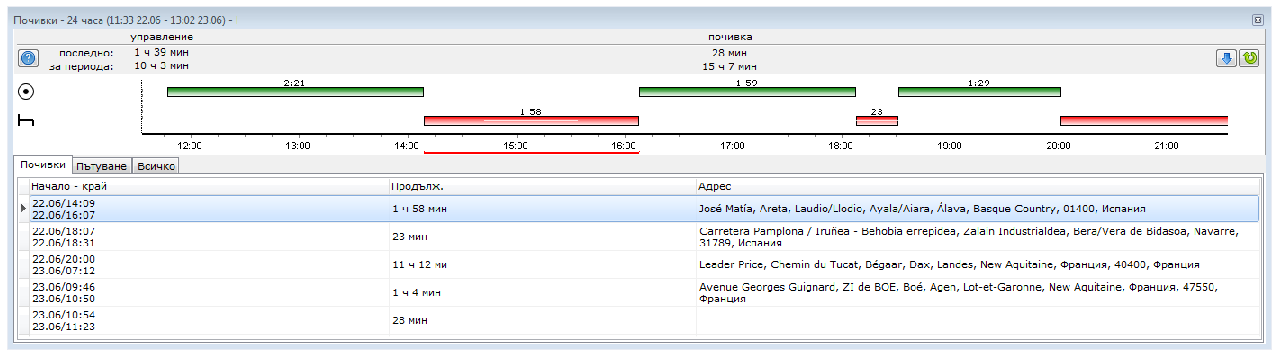
On a client level, GPS Logistic offers both reports for past period of time and for monitoring data from the mobile object in real time. In real time, the available data from the vehicle varies depending on the number of additional modules, installed to the GPS tracker. Most commonly, the data includes: current position of the vehicle, position of the ignition key – On/Off, status of the engine – working/at rest, movement speed, fuel level in the tank (if available) and etc. For past period of time, the system has the following queries: Statistics – a report that represents a calendar with data for the completed tasks (sorted by date) for each vehicle or machine – work time, total engine working time, travelled distance, refuelings, signalizations for suspicious fuel level drops, fuel consumption, maximal speed for each day and so on, Waybill – an electronic document for travelled distances and routes in text format, module Service intervals – throughout which the Customer can add forthcoming checks and technical events to their machines – in order to receive timely notifications about them. The system also has a report named “Tacho”, in which can be seen information regarding the working status of the vehicle – in motion/at place – for the last 24 h. This helps the fleet managers to calculate the remaining driving time of the vehicle and/or the required duration of the next rest.
In case a more detailed investigation of the travel of a vehicle or of the working day of a machine is required, the Customer can access the stored “trace” of the activity of the client. The visibility of additional data depends on the count of peripheral modules connected to the GPS tracker.
Queries on a driver level are accessible for the vehicles with installed additional module for driver identification in one of the 2 variations: 1. driver identification module with the use of RFID chip or card or 2. module for reading the number of the driver card, placed in the tachograph of the truck. This option grants access to reports for travelled distances by a driver for a set period of time, report for the operated vehicles by a chosen driver for a given time frame and also the option enriches documents as the electronic Waybill, the “trace” of the vehicle and so on with information about the driver, that was driving it through the respective segment. There is also a scenario at which the drivers name can be hardcoded to a vehicle, but then the reports on driver level will become identical with those at client level.
On a static object level, the system gives options for generating reports about the objects, visited by a chosen client, as well as, a report for the clients, which have vistited a chosen object. For this purpose, the Customer has to add the objects at GPS Logistic in advance. This can be performed via the object editor of the system. There is also an option for adding an object list from a file. The addition of static objects enriches the graphic “trace” of the client in order the Customer to be able to see at which objects the vehicle had stopped during the day and to monitor the positions of the vehicles compared to those of the objects – in real time. This also enriches the data from Waybill, as the Customer can choose whether to see the address of the stop on the map or the names of the objects in the document. There can also be random data combinations – for instance, a report for the visited objects by a vehicle, with additional information about the temperature from a refrigerated trailer upon entrance/leaving from the object, time of stay at the object, number of visits to the object for a given period and etc.
On the additional equipment level, the system has to offer reports similar to the driver quieries – throughout which days and how many kilometers the additional equipment has travelled (e.g.: trailer), equiped to which vehicles and from when to when it was seen in the system, where it was seen for the last time and so on.